


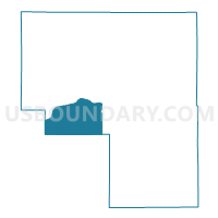
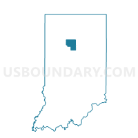
18 CLINTON, Cass County, Indiana
About
Outline

Summary
| Unique Area Identifier | 576562 |
| Name | 18 CLINTON |
| County | Cass County |
| State | Indiana |
| Area (square miles) | 25.08 |
| Land Area (square miles) | 24.69 |
| Water Area (square miles) | 0.38 |
| % of Land Area | 98.47 |
| % of Water Area | 1.53 |
| Latitude of the Internal Point | 40.72502460 |
| Longtitude of the Internal Point | -86.45647300 |
Maps

Graphs
Select a template below for downloading or customizing gragh for 18 CLINTON, Cass County, Indiana


Neighbors
Neighoring Voting District (by Name) Neighboring Voting District on the Map
- 21 EEL WEST, Cass County, IN
- 24 JEFFERSON, Cass County, IN
- 29 WASHINGTON, Cass County, IN
- 33 NOBLE NORTH, Cass County, IN
- 35 WASHINGTON CITY, Cass County, IN
- 40 CLINTON CITY NV, Cass County, IN
- ADAMS, Carroll County, IN
- LIBERTY, Carroll County, IN
- WASHINGTON, Carroll County, IN
Top 10 Neighboring County Subdivision (by Population) Neighboring County Subdivision on the Map
- Eel township, Cass County, IN (18,767)
- Noble township, Cass County, IN (1,960)
- Washington township, Cass County, IN (1,608)
- Jefferson township, Cass County, IN (1,452)
- Clinton township, Cass County, IN (816)
- Washington township, Carroll County, IN (549)
- Adams township, Carroll County, IN (516)
- Liberty township, Carroll County, IN (440)
Top 10 Neighboring Place (by Population) Neighboring Place on the Map
Top 10 Neighboring Unified School District (by Population) Neighboring Unified School District on the Map
- Logansport Community School Corporation, IN (24,000)
- Twin Lakes School Corporation, IN (14,685)
- Delphi Community School Corporation, IN (9,651)
- Southeastern School Corporation, IN (8,447)
- Carroll Consolidated School Corporation, IN (6,571)
- Pioneer Regional School Corporation, IN (5,196)
Top 10 Neighboring State Legislative District Lower Chamber (by Population) Neighboring State Legislative District Lower Chamber on the Map
Top 10 Neighboring State Legislative District Upper Chamber (by Population) Neighboring State Legislative District Upper Chamber on the Map
Top 10 Neighboring 111th Congressional District (by Population) Neighboring 111th Congressional District on the Map
Top 10 Neighboring Census Tract (by Population) Neighboring Census Tract on the Map
- Census Tract 9518, Cass County, IN (3,972)
- Census Tract 9511, Cass County, IN (3,065)
- Census Tract 9593, Carroll County, IN (3,023)
- Census Tract 9594, Carroll County, IN (2,592)
- Census Tract 9510, Cass County, IN (2,458)